Type: Lab
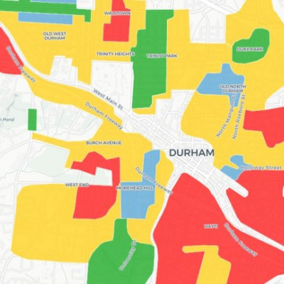
In Fall 2020, the Durham project team investigated the practice of redlining, a post-Depression-era discriminatory housing practice in which lenders categorized and rated neighborhoods according to their insurability based upon racial and other factors, between the post-bellum and urban renewal periods. Nationally, the outcome of this practice was that very few FHA insured homes were sold to people of color in the subsequent decades. Locally, longstanding variations in community investment and property values continue to have effects on the urban fabric and the experience the city’s inhabitants.
To help students explore this topic, the Durham team created an R tutorial for building an interactive map based on the 1937 Home Owner Loan Corporation’s Residential Security Map of Durham.
By actively creating an interactive map, students are encouraged to think through how consequential such visual and quantitative representations of urban space can be, and how maps can both create a reality, and reflect it. The Durham team conceived of this exercise as just a starting point, and one of several possible approaches to mapping Durham history, and with the potential to add in additional data layers, testimonies, and other media to help explore the presence of the past in Durham’s challenges today. We anticipate building upon this exercise in future semesters of the Digital Durham history and digital humanities course, and related projects.